


IMD sounds 48-hour red alert in Odisha as low pressure intensifies

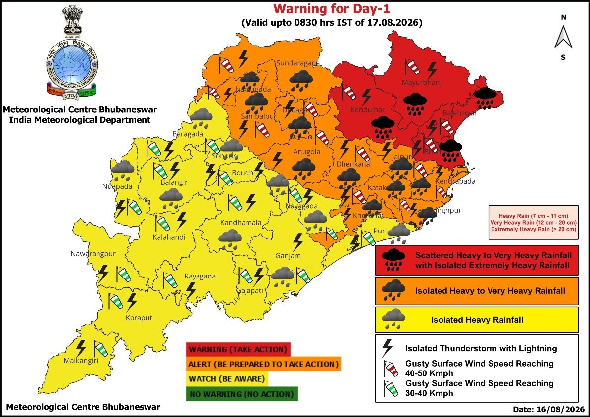
Bhubaneswar:The low-pressure system over the Northwest Bay of Bengal and adjoining West Bengal–North Odisha coasts is expected to intensify over the next 24 hours, bringing heavy to extremely heavy rainfall to Odisha.
According to the Met office special bulletin released on Sunday afternoon, a red warning for heavy to very heavy rainfall, with isolated extremely heavy downpours, has been issued for Baleshwar, Bhadrak, Kendujhar, and Mayurbhanj districts. The red alert will continue for Baleshwar, Kendujhar, and Mayurbhanj into the second day as well.
Meanwhile, an orange warning for heavy to very heavy rainfall covers central and northern districts including Jajpur, Kendrapada, Jagatsinghpur, Kataka, Khordha, Sundaragada, Jharsuguda, Sambalpur, Debagada, Anugola, Dhenkanal on August 16; and Bhadrak, Jajpur, Kendrapada, Jagatsinghpur, Kataka, Sundaragada, Jharsuguda, Sambalpur, Debagada, Anugola, Dhenkanal on August 17.
Thunderstorm accompanied by lightning and gusty surface wind (40-50 kmph) may occur at one or two places in the districts of Baleshwar, Bhadrak, Jajpur, Kendrapada, Jagatsinghpur, Kataka, Sundaragada, Jharsuguda, Sambalpur, Debagada, Anugola, Dhenkanal, Kendujhar, Mayurbhanj and Khordha on August 16; and Baleshwar, Bhadrak, Jajpur, Kendrapada, Jagatsinghpur, Kataka, Sundaragada, Jharsuguda, Sambalpur, Debagada, Anugola, Dhenkanal, Kendujhar and Mayurbhanj on August 17.
Yellow warnings for isolated heavy rainfall along with thunderstorms and gusty winds have been sounded across various interior and southern districts, including Puri, Ganjam, Balangir, Boudh, and Nayagada, on these two days.
Heavy to very heavy rain may continue at one or two places over Sundaragada, Jharsuguda, Baragada, Sambalpur, Debagada, Kendujhar, and Mayurbhanj on August 18. Heavy rain is also expected in Baleshwar, Bhadrak, Jajpur, Anugola, Dhenkanal, Sonpur, Boudh, Nuapada, Balangir and Kalahandi districts.
The weather agency has also warned of squally wind speeds reaching 40 to 50 kmph, gusting up to 60 kmph, along and off the Odisha coast till August 18. Fishermen have been advised to strictly avoid venturing into the sea, which is expected to remain rough to very rough. Local Cautionary Signal No.-III (LC-III) will remain hoisted at all ports across Odisha.
Authorities have cautioned residents about localised flooding, urban waterlogging, potential landslides in hilly regions, disruption of rail and road transport, and minor damages to kutcha structures, electrical lines, and standing crops. People in vulnerable areas have been advised to monitor weather updates, remain indoors during intense rain spells, avoid shelter under trees, and stay prepared to move to safe locations if conditions deteriorate. State disaster management authorities, district collectors, and municipal administration teams have been alerted to handle emergency situations.
Odisha is staring at another flood-like situation this monsoon season amid the red warning for 48 hours and severe torrential downpours recorded in several parts of the state over the past 24 hours, ending at 8:30 am on August 16. Banspal in Kendujhar registered the highest rainfall at 14 cm, followed by Barkote in Deogarh, Tensa, Gurundia, and Bonai in Sundargarh, and Jamankira in Sambalpur, all recording between 11 cm and 13 cm. Kendujhargada and Telkoi also witnessed heavy spells reaching up to 11 cm.

Comments are closed.